

Craig Goch [Mynydd Cwmcelli]
Good walks are even better shared.
SH8009 : Mynydd Cwmcelli
Steven Brown Photo source
Overview
Craig Goch [Mynydd Cwmcelli]
Overview
Craig Goch, standing tall at 665 meters, is a prominent feature of the Brecon Beacons in Wales. Known for its breathtaking views, this mountain is a favourite among hikers looking to soak in the natural beauty of the area. Its status as a Marilyn attracts enthusiasts who relish the challenge of scaling its slopes.
Geology
The mountain comprises sedimentary rocks that date back to the Carboniferous era. The area's geology supports diverse ecosystems and hides stories of ancient marine life in its fossils—perfect for those with a penchant for history!
Routes
Hikers can enjoy various routes, such as the Lake Vyrnwy Circuit, ideal for those wanting a moderate, picturesque hike. Alternatively, the Llyn Mwyngil to Craig Goch route offers a more challenging trek through enchanting moorlands.
Summit Features
At the summit, you'll find a sturdy stone cairn, providing a perfect backdrop for your summit selfie! Don’t forget to pack a snack and enjoy a picnic with stunning views all around you.
Terrain Type
Expect a mixed terrain of grassy expanses with rocky outcrops throughout your journey. Watch your step, especially when encountering slippery rocks after rainfall!
Views
The panoramic vistas from Craig Goch are particularly stunning—on clear days, you can admire the serene Lake Vyrnwy and the sprawling Brecon Beacons. Spring and early autumn are the best times to visit to catch those spectacular scenes.
Hazards
As always in the great outdoors, conditions can change rapidly. Be prepared for shifting weather patterns and take care on rockier sections of the trail.
Nearby Summits
Adventure seekers can also explore nearby summits like Moel Llechwen and Mynydd Cwm Bwch, which offer further opportunities for exploration and incredible views.
Access
Visitors typically park at the Llyn Mwyngil car park. Public transport options are available, but be ready for a good walk to reach the trails. Llanwddyn, the nearest town, has charming facilities for a post-hike treat.
Facilities
Llanwddyn is your go-to for refreshments, with a quaint café and local shops to cater to your needs. After a long day on the trail, what could be better than a warm cup of tea?
History
The name 'Craig Goch' means 'Red Rock,' a fitting description of the mountain’s stunning hues. This area is rich in cultural significance, with ancient settlement sites nearby that tell tales of the past.
Whether you're a seasoned hiker or an eager novice, Craig Goch welcomes you with open arms and unforgettable sights. Happy hiking!
Explore routes near Craig Goch [Mynydd Cwmcelli]
Walks starting near this hill. Open a route to check its map, distance and full itinerary.
Waun-oer, Maesglase and Cribin Fawr guided mountain walk
View route
Cadair Idris - Pony Path
View route
Mawddach Trail: Penmaenpool to Arthog Estuary Return
View route
Mawddach Trail: Penmaenpool to Dolgellau Riverside Return
View route
Route planning notes
These notes describe possible approaches. Check a route's map and access information when planning your walk.
Lake Vyrnwy Circuit
A circular route that provides stunning views over Lake Vyrnwy while gently ascending to the summit of Craig Goch.
Llyn Mwyngil to Craig Goch
This route takes you from the shores of Llyn Mwyngil up to the summit, passing through lush moorland.
Make a day of it, together
Find someone to share the walk with, or organise a day out along a route you like.
Photo Gallery
View all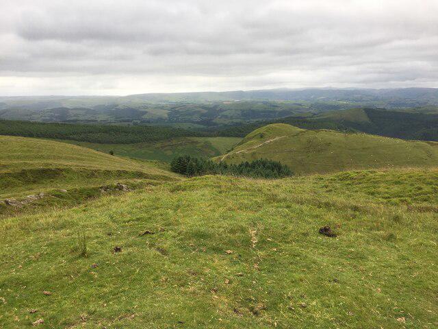 Photo could not load
SH8009 : Mynydd Cwmcelli
Steven Brown
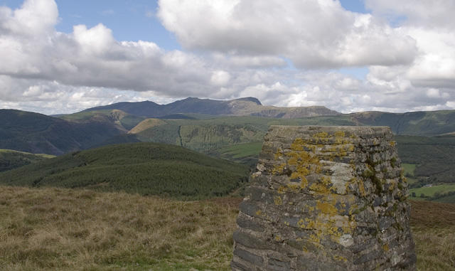 Photo could not load
SH8009 : Mynydd Cwmcelli summit trig point
Vivien and Geoff Crowder
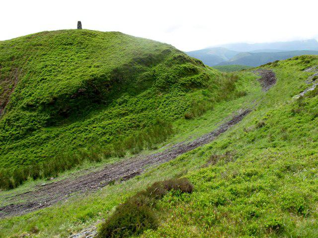 Photo could not load
SH8009 : Mynydd Cwmcelli
Rude Health
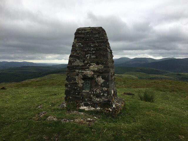 Photo could not load
SH8009 : Trig point on Mynydd Cwmcelli
Steven Brown
Hill facts and local notes
Classifications
Elevation
468m
1,536 ft
Prominence
156m
Coordinates
52.6741, -3.7695
SH804099
OS Map
124 125
Explorer: OL23E 215W
At the Summit
The summit features a prominent cairn, which is a popular spot for taking photographs. There's also a lovely flat area perfect for a picnic—just don’t forget your sandwiches!
Terrain & Geology
The mountain is primarily composed of sedimentary rocks, including mudstones and sandstones, typical of the region, which formed during the Carboniferous era. This geological composition provides a rich tapestry for fossils, so keep an eye out for ancient marine life!
Views & Scenery
From the summit, you can see the expansive views of the Brecon Beacons, as well as the shimmering waters of Lake Vyrnwy. On a clear day, the sight is nothing short of breathtaking.
History & Heritage
Name Origin
The name 'Craig Goch' translates from Welsh to 'Red Rock', likely referring to the reddish hues of the local rocks.
Historical Significance
This area has a rich cultural history, with remnants of ancient settlements found nearby. It is also a popular destination for walking and outdoor activities.
Getting There & Facilities
Parking
There is ample parking near the starting point at the Llyn Mwyngil car park, which can accommodate a good number of cars. Please note that parking fees may apply.
Public Transport
Buses frequently run from nearby towns, such as Welshpool and Machynlleth, which can get you reasonably close. However, expect a bit of a hike to reach the trailhead.
Nearby Facilities
While the mountain itself has no facilities, Llanwddyn offers a café and some small shops for any necessities, including coffee to fuel your adventure.
Safety Information
Known Hazards
- Keep an eye out for sudden weather changes typical in the area, as well as slippery rocks, especially after rain.
General Safety Tips
- Check weather conditions before setting out
- Carry appropriate clothing and equipment
- Let someone know your planned route
- Take a map, compass, and GPS device
- Carry emergency supplies: food, water, first aid kit, torch
Hills
Some common questions about the hills answered
Are there group walks up Craig Goch [Mynydd Cwmcelli]?
Many walkers use Walkmates to join or organise walks with others. You can check for group walks around Craig Goch [Mynydd Cwmcelli] through the maps
Are there other walkers around Craig Goch [Mynydd Cwmcelli]?
Activity varies by location and time, but Walkmates lets you see whether others have shared walks or shown interest in this area. Find other people through the walking friends search walking friends for Craig Goch [Mynydd Cwmcelli] search or of course create your own walk for Craig Goch [Mynydd Cwmcelli]
Can I organise a walk to Craig Goch [Mynydd Cwmcelli]?
Yes. If there aren’t any walks listed already, you can create a walk and make it available for others to join.
If you're signed up to Walkmates, you can create a walk to Craig Goch [Mynydd Cwmcelli].
How do I find a walk up this hill?
There are often multiple ways to walk this hill, depending on experience and route preference. Walkmates helps you explore walks and routes that others have shared.
Can I suggest a new route up Craig Goch [Mynydd Cwmcelli]?
Yes. You can suggest or create routes to share with others. Walkmates focuses on the social side of walking, so routes are used to help people organise walks and explore areas together, rather than as detailed navigation tools or route libraries.
Other uses really appreciate knowledgeable walkers sharing their routes. Share your favourite route to Craig Goch [Mynydd Cwmcelli] here
The is an error or something incorrect about this hill. How do I let you know?
We always strive to keep the information on Walkmates as accurate as possible. If you find an error, please let us know through the contact form and we'll aim to correct it as quickly as possible
Community Discussion
Comments
Location
![Craig Goch [Mynydd Cwmcelli] location map](https://cdn.walkmates.com/hill-maps/hill-sources/2155/52.67408_-3.76945.png)
Grid reference: SH804099
View on OpenStreetMapOpens a map in a new tab, centred on the hill.
Nearby Hills
Aran Fawddwy
906m
Cadair Idris - Penygadair
893m
Y Garn
629m
Pumlumon Fawr [Plynlimon]
753m
Arenig Fawr
854m
No comments yet. Be the first.